Branson, MO Lakes
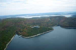
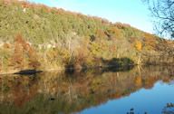
Table Rock Lake
Table Rock Dam, located on the White River approximately 6 miles southwest of Branson, was completed in August of 1958. The dam, constructed from more than 1.2 million cubic yards of concrete, was created primarily for flood control, hydroelectric power and water supply. Table Rock is a link in a chain of power producing stations that provide about seven million end-use customers in six states (Arkansas, Kansas, Louisiana, Missouri, Oklahoma and Texas) with power to meet peak demand periods.
It has a maximum height of 252 feet above the river bed and an overall length of 6,423, of which 4,821 feet is an earthen embankment. Encased in the dam are ten 45′ x 37′ spillway floodgates. Table Rock Lake has a surface area of approximately 43,100 surface acres, 745 miles of shoreline, and a lake elevation above mean sea level of 915 feet at the top of the Conservation Pool and 52,300 surface acres, 857 miles of shoreline, and a lake elevation above mean sea level of 931 feet at the top of the Flood Control Pool.
Table Rock Lake offers a wide variety of recreational activities including hiking, sightseeing, hunting, skin diving, fishing, and numerous water sports such as swimming, boating, water skiing, water boarding, and more. People accessing Table Rock Lake from the Branson area will be able to enjoy all that Table Rock Lake has to offer plus the Activities Food, Lodging, and Shopping and Shows that are available within the Branson Tri-Lakes Area.
Bull Shoals Lake
Bull Shoals Dam, located on the White River seven miles north of Cotter, Arkansas, was completed in July of 1951. As the fifth largest concrete dam in the United States, it has a height of 256 feet above the river bed at its highest level and runs 2,256 feet in length. With 17 Spillway Crest Gates, Bull Shoals Lake has a surface area of approximately 45,440 surface acres, 740 miles of shoreline, and a lake elevation above “mean sea level” of 654 feet at the top of the Conservation Pool. At the top of the Flood Control Pool, the lake has 71,240 surface acres, 1,050 miles of shoreline, and a lake elevation above “mean sea level” of 695 feet.
Bull Shoals Lake offers a variety of recreational activities including hiking, sightseeing, hunting, skin diving, fishing, and water sports such as swimming, boating, water skiing and more. People accessing Bull Shoals Lake from the Branson area will have the best of all worlds, with access to all that Bull Shoals Lake has to offer plus the Activities Food, Lodging and fun available in Branson.

Lake Taneycomo
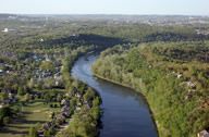
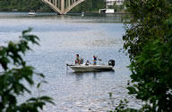
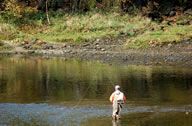
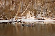
Lake Taneycomo’s cold clear waters provide some of the finest trout fishing available anywhere in the world. The Rainbow Trout and Brown Trout that ply the waters of Lake Taneycomo provide an exciting, year-round fishing experience. From fly fishing and artificial-only fishing in the Trophy Trout Area near the lake’s headwaters, to bait fishing outside of the Trophy area, Lake Taneycomo makes angling for coveted Rainbow and Brown Trout a rewarding experience. Numerous state records have been earned in Taneycomo’s waters.
Lake Taneycomo (short for Taney County Missouri) was created in 1913 when the White River was captured by the newly constructed “Power Site” Dam, near Forsyth, Missouri. The completion of Table Rock Dam in 1958, 22 miles upstream, created a southern boundary for the Lake which now consists of over 2,080 surface acres. Unlike the Table Rock and Bull Shoals Dams and Lakes, which are owned by the U.S. Army Corps of Engineers, the Power Site Dam is privately owned by Empire Electric Company. This company holds a license to continue operating the Dam and its hydroelectric plant until 2022.
From 1913 until 1958 Taneycomo was a “warm water” lake, but when Table Rock Dam started feeding Taneycomo, the water coming through the “power generators” was significantly lower in temperature. Virtually overnight, a “cold water” fishery was created. To take advantage of this change, the Missouri Department of Conservation constructed the “Shepherd of the Hills Trout Hatchery” at the foot of the Dam.
Warning: When fishing near the Table Rock Dam from the Bank or particularly when wading pay attention to the horn when it blows. This is a warning indicating that they are going to start generating power. This will cause a sudden increase in the speed of the current and depth of the water. The water can rise feet in a matter of minutes.
Note: The majority of the shore on Lake Taneycomo is private property; shore fishing is limited to the public land in state and municipal parks along the shoreline. Additional shore fishing is available at the many trout docks located along the lake call the specific resort or trout dock to check their availability.